Damselfly believed to be extinct from Island rediscovered
By Peter Duncan, Senior Marine Environment Officer with the Isle of Man Government.
Ours seas are difficult places to work in, and it’s not just wind and waves that makes it so.
Here on the Isle of Man, the sea is literally all round us; whether we travel on it, work on it or just play and look at it, there really is no escape.
But in some ways it’s that familiarity that causes the difficulties of trying to promote its importance and novelty; because we all know it so well, we already have pretty fixed ideas about it and, like our ancestors, the idea that the sea is constant, never changing and will always be there for us, is deeply ingrained.
But actually, it isn’t so constant, we’re already recording long-term sea surface temperature changes around the Island, our fish stocks have come, gone and come back again, but it’s clear they need close management.
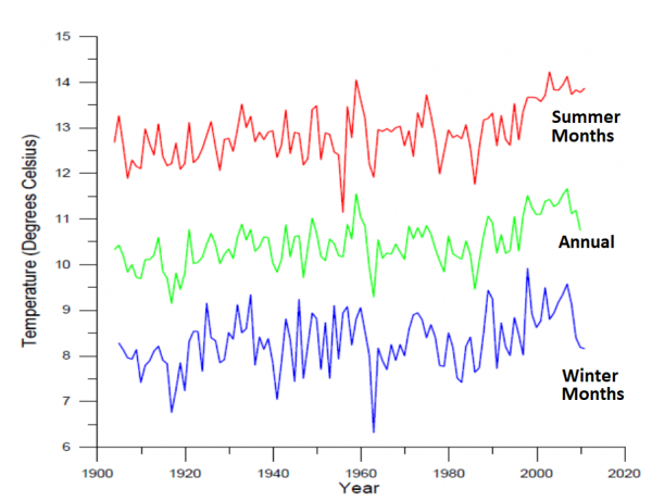
Port Erin Bay sea surface temperature time-series 1904-2011. Averaged summer (June, July, August)(RED) and winter (December, January, February)(BLUE) temperatures. The GREEN line represents annual mean temperature
And actually, the sea has become increasingly important to us in recent years, from regional fishing rights and ensuring that it can continue to provide our favourite seafood, to its critical role in fighting climate change, finding space for renewable energy projects, or protecting the biodiversity that provide so many of our ecosystem services; ie. the things that nature does for us, even though we don’t always appreciate them.
So, working in marine science, conservation and management has always been a challenge, and now there is a new list of reasons to raise the profile and engage everyone in marine things; from ourselves as individuals to our politicians and business leaders. So how do we do that when we may already think we know what our seas have to offer us?
One method of doing it is by recognising that marine conservation is important enough for us to have designated more than 50% of our inshore waters as Marine Nature Reserves.
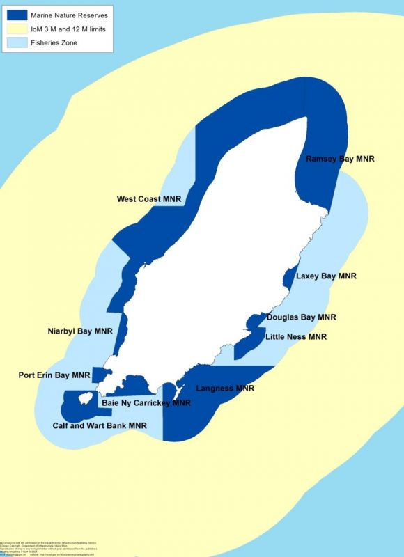
Map of the ten Manx Marine Nature Reserves (dark blue), all within the 0-3 nautical-mile inshore area. They cover 430 km2, or approximately 11% of the territorial sea
That’s quite a commitment for a small Island, and was done to meet our international treaty obligations, as well as our local interests, such as ensuring good recreation and wildlife experiences as well as looking after our fish stocks. It’s also a great testament that we have some amazing wildlife to protect.
But, Marine Nature Reserves, as part of our UNESCO Biosphere, are also for people to enjoy and use sustainably, and so it’s important that there is enough information available to enable that to happen.
With the new and comprehensive guides and spotter sheets, each of our ten Marine Nature Reserves has received a personal touch.
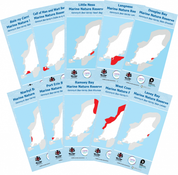
The Manx Marine Nature Reserves guides, available in hard copy or online
You can find out where, why and what is in each MNR, and then spend time looking for some highlights. We’ve made it fairly easy to start, with everything observable from dry land, but maybe it will lead to a bigger interest and serious rockpooling may turn to snorkelling and diving! One of our really dedicated rock poolers has now found more than 180 species in Douglas Bay alone, and we have some of the best diving to be found anywhere.
The guides and spotters are available in printed format, from DEFA (St John’s), Manx Wildlife Trust in Peel and the Welcome Centre at the Sea Terminal in Douglas. They are also available to download from the Government website via the internet or QR code.
So, find the MNR guide and spotter sheet that’s closest to you, and go and enjoy our fantastic marine and coastal wildlife.
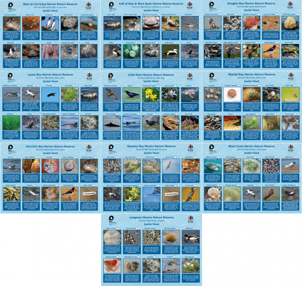
The Manx Marine Nature Reserves spotter sheets, which highlight some of the different animals and plants in each reserve, available in hard copy or online.
What are marine nature reserves?
- The Island has 10 marine nature reserves (MNRs), which are also the marine core areas of Biosphere Isle of Man.
- They are areas of sea, legally-designated under the Wildlife Act 1990, for the conservation of marine animals, seaweeds (flora and fauna) and habitats, and also for providing opportunities for study and research.
- They are the marine equivalent of National Nature Reserves on land, of which there is one; The Ayres National Nature Reserve.
- The MNRs cover 430 km2 of our territorial sea (which is 3970 km2, and extends approximately 12 nautical miles (M) from the coast); so around 11% (10.8%) of the whole territorial sea and nearly 52% of the inshore marine area (0-3M).
- All of the MNRs are within the inshore 3M area of the territorial sea, and are designated up to the Highest Astronomical Tide, so they also help protect the shore and coastal habitats, especially when they coincide with other protected sites, such as coastal Areas of Special Scientific Interest (ASSIs).
Why were they created?
The MNRs provide two main functions;
Firstly, they form an ecological network, linking and protecting the majority of the important conservation species and habitats around the Island. Some MNRs protect specific habitats and species, but most include a range of different types.
The Isle of Man also made a commitment under the UN Convention on Biological Diversity, which we signed in 2012, to have at least 10% of our waters within marine protected areas, which was met in 2018 with the designation of the MNRs.
Secondly, and reflecting the origins of some of them, they also help protect fisheries species and their habitats from some types of commercial fishing - in particular dredging and trawling for king scallop and queen scallop, although some parts of the MNRs also help conserve other commercial species such as crab, lobster and whelk.
Maintaining some unfished populations of our important commercial species within marine nature reserves, means they can play a critical role in helping restock areas that have been harvested. The Isle of Man has a diverse and rich marine environment, but it is increasingly used for a wider range of human activities, from pipelines, windfarms and gas exploration, internet and electricity cables to shipping, sewage treatment, eco-tourism and fisheries. Government must therefore find ways to balance our social and commercial needs with those of the natural fauna and flora.
A high-quality marine environment provides greater resilience from disturbance and climate change, and delivers better ecosystem services.
It has been recognised internationally and around the Island, that marine protected areas (MNRs in our case) improve environmental quality and help deliver a range of benefits for marine life and humans. Most marine management regimes around the world typically include such areas.
What marine creatures do they protect?
Every MNR has its own designation features that enabled them to qualify for legal protection. These designation features may be the most important species or habitats occurring there, but they are not the only ones, and often by protecting the designation features it also benefits a much wider range of species.
Examples include:
Douglas Bay MNR – Beaumont’s seaslug, (Cumanotus beaumonti) a rare species and only known from the Isle of Man, Northern Ireland, Western Scotland and Norway.
Little Ness MNR – some of the best horse mussel reefs in the British Isles, and home to more than 296 different marine animals and seaweeds.
Langness MNR – as well as eel grass meadows, it’s probably the best place to see Risso’s dolphin, which feed off the Peninsula in summer.
Baie ny Carrickey MNR – includes the spectacular Sugar Loaf sea stack, the island’s most important nesting site for guillemot, razorbill and kittiwake, and is best observed from the Chasms, near Port St Mary.
The Calf of Man and Wart Bank MNR – the underwater habitats are probably best seen from under the water by diving, but the Calf also has the highest number of grey seals around the island - best seen from The Calf Sound, or by a specific boat trip from Port St Mary or Port Erin.
Port Erin Bay MNR - contains important scallop populations, protected since 1989, including from scuba diving. The bay also has good bird watching – including cliff-nesting fulmars, ravens and gannets.
Niarbyl Bay MNR – basking shark, grey seals and seabirds, as well as spectacular coastal scenery.
West Coast MNR – the best area for basking shark, but various sea and coastal birds – and diverse scenery from rocky inlets to sand cliffs.
Ramsey Bay MNR – the island’s best eel grass meadow, extensive horse mussels reefs, seabirds (including puffins), brittlestar beds and good seafish angling; in part due to its protection since 2011.
Laxey Bay MNR – eel grass meadow, extensive sandy seabed with some of our rarest and long-lived bivalve molluscs- such as Arctic clam and fan mussel. Also good for seabirds and marine mammals, such as bottlenose dolphin and porpoise.
What can people gain from looking at MNR Leaflets and Spotter Sheets?
The new leaflets and spotter sheets cover all 10 of the MNRs around the Island’s coast, and so there will be one covering your local marine reserve.
The leaflets provide the public with information about why the MNRs exist, what can be found within them, and importantly how they can be enjoyed safely.
The spotter sheets also show some highlights of each reserve, and provide an opportunity for families to enjoy a simple activity in their local MNR.
The leaflets also link to other activities, such as coastal footpaths, tourist trails and the coastal Areas of Special Scientific Interest, which are also accessible to the public, and which provide additional opportunities for exploring the Manx coast.
Where can I get the leaflets and spotter sheets?
The new guides are available from DEFA Headquarters at St John’s, and online at www.gov.im/mnr, where they can be downloaded to your phone or device.
You can also scan the QR code here to access them.
They have been developed in collaboration with Manx Wildlife Trust, and will be available from its office in Market Square, Peel, and at the Welcome Centre at the Sea Terminal, Douglas.
The guides were officially launched during Schools' Biosphere Week (27th June – 1st July).
Funding for the guides and spotter sheets has been provided by Manx Utilities.
Main photo: Tony Glen
Posted up on 24th July 2022


