World Biosphere Day: Clare Barber MHK
Explore the Isle of Man's 10 Marine Nature Reserves (MNRs) on #MarineMondays. This week, in part one of a three-part article, Dr Peter Duncan, Senior Marine Environment Officer for the Isle of Man Government, describes some of the vital species and habitats that come under protection in Ramsey Bay:
Ramsey Bay MNR, or Kemmyrk Bea-Varrey Baie Rhumsaa, was the very first marine nature reserve for the Isle of Man, designated in 2011.
The Wildlife Act 1990, the primary environmental protection legislation of the Island, provides the power to designate areas of special conservation interest, including Areas of Special Scientific Interest (ASSIs), National Nature Reserves (eg. The Ayres NNR), and Marine Nature Reserves (all 10 of those big, wet, wobbly things).
However, while nine MNRs were designated in relatively short order in 2018, the first one in Ramsey Bay – which laid the groundwork for the rest - took several years of consultation, hard work and a bit of luck to establish.
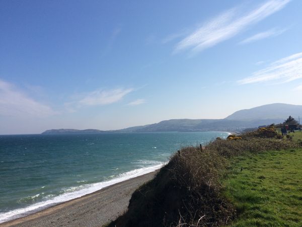
Ramsey Bay looking south
The Isle of Man marine nature reserve project began in 2008 with the collation of existing data and new survey work to identify the Island’s most important marine habitats and species for protection.
Options were presented during a lengthy consultation process that showed a high level of enthusiasm for setting up a new MNR, with Ramsey Bay the prime candidate on account of its size, habitat diversity and local public support.
However, it arguably took a turn of misfortune to get things really moving, and that was a period of scallop overfishing that culminated with the first (and so far only) emergency closure of a Manx fishing ground in December 2009.
The Manx Fish Producers’ Organisation (MFPO) was faced with something of a gamble; either wait for a possible fishery recovery and a return to ‘business as usual’, or take a chance on a fishery co-management trial in a newly-created Fisheries Management Zone within a zoned Marine Nature Reserve.
Arguably, it was also a gamble for marine conservation, since at face-value, scallop dredging and protected areas seldom co-exist in that way.
Anyway, to simplify a complicated story: with the important backing of the fishing industry, the new Ramsey Bay MNR was set up to consist of five different zones: four for conservation and one for sustainable fisheries management. The conservation and fishery-designated areas were roughly the same size, at 47 and 47.5 km2 respectively (and total MNR area of 94.5 km2), with each zone containing the most important protected features or fishing grounds as appropriate.
Ramsey Bay MNR zones:
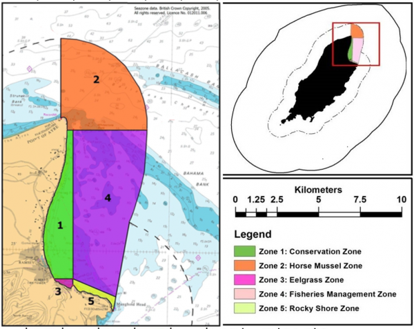
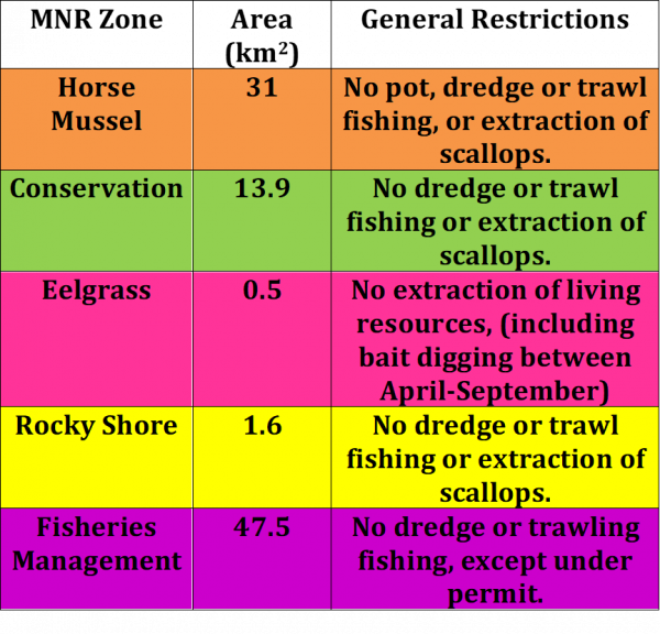
The Horse Mussel Zone:
Ramsey Bay has a good population of horse mussels (Modiolus modiolus) - the giant cousins of the more familiar blue mussels, and the horse mussel zone (shown in orange on the map) is there to protect them.
Off the Point of Ayre they form a proper biogenic reef; a great mass of mussels forming a raised ‘hump’ on the seabed, covering up to 6 km2, although they also occur buried in the seabed in large numbers in the north of the fisheries management zone.
As with Little Ness MNR, horse mussel reefs provide numerous ecological services, not least of all a home for lots of other ‘greeblies’ (a technical term for sea creatures).
While Little Ness had 296 identified species living in its crevices, the Point of Ayre reef was not far behind, at 270, making it the fourth most biodiverse reef surveyed around the British Isles.
The fast-moving currents in this area deliver plenty of food, making it a perfect habitat for filter feeders, like mussels, and suspension feeders, like dead man’s fingers (soft coral). Both species seem to occur together, the soft corals visible as white blobs in the photograph, which actually makes spotting horse mussel reef much easier.
-reef-(rohan-holt).jpg)
Modiolus (horse mussel) reef with conspicuous dead man's fingers (soft coral) (Rohan Holt)
This area has had quite a lot of scientific investigations over the years, including using scanning sonar equipment, which actually visualises the raised reef structure on the seabed.
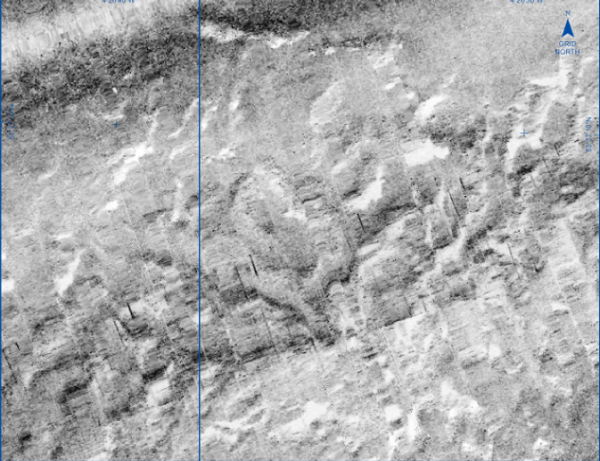
Side scan sonar showing lumpy horse mussel reef
Of course, it’s important to ‘ground truth’ sonar images with video or physical sampling to confirm the habitat, and that also provides estimates of mussel density, as well as samples for other species identification. In these ways we can start to build up a picture of what we’re trying to protect, and set a benchmark to monitor changes, both positive or negative.
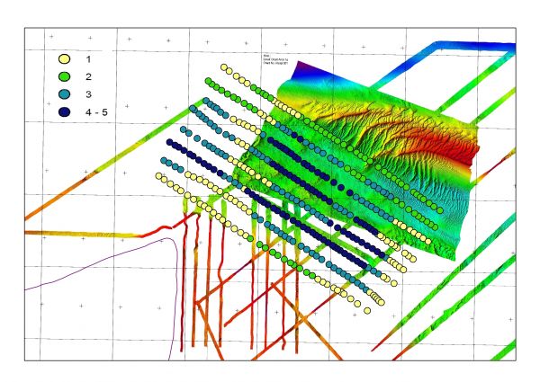
Point of Ayre horse mussel reef; sonar imaging and density estimates
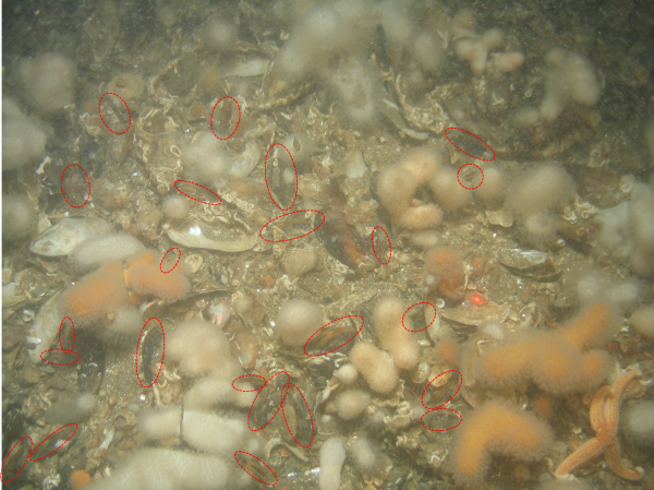
Horse mussel bed image analysis and soft corals. Red circles are mussels
The complex, interconnecting, structure of horse mussel reef is vulnerable to bottom-towed fishing gear, particularly scallop dredges. Earlier research work on this reef demonstrated this (Cook et al., 2013 - see references), and the lengthy recovery times involved.
As such, zoning provides a mechanism to separate incompatible habitats and activities. However, and this is why fishing industry support has been critical for MNR success, there must be benefits for both parties - hence the inclusion of a Fisheries Management Zone from the beginning.
The Conservation Zone:
This inshore area (shown in green on the map) contains a lot of different habitat and species, but perhaps the most important are kelp forest and the coralline (stony) red algae called maerl. Encrusting coralline algae can be found easily on most rocky shores, but maerl is free-living, and refers to several species of slow growing (~1 mm per year), branching forms.
As algae they photosynthesise like plants, and so live in relatively shallow depths down to around 30 metres, but their branching structure provides lots of spaces for other animals, and their oxygen-producing photosynthesis, combined with current flow, provides a good, well-protected, habitat.
As such, they create a suitable home for many other species, and a wonderfully-coloured backdrop for underwater photographers.
.jpg)
Ramsey Bay Maerl bed (Dr Fiona Gell)
.jpg)
Maerl and hermit crab (Jim Self)
Maerl was commonly collected as fertiliser for agriculture, but its acknowledged importance in marine ecosystems means that practice has become more restricted. Similarly, its slow growth rate and fragile nature means it doesn’t get along with towed fishing gear, so dredge and trawl is excluded from this zone.
However, at least one important function of maerl beds is their role as a nursery for commercial species such as queen scallops. Experiments have shown that juvenile scallops, called spat, have a distinct preference for maerl-rich sediments compared to plain sand/gravel, and so scallop fisheries do still benefit from this zoned approach.
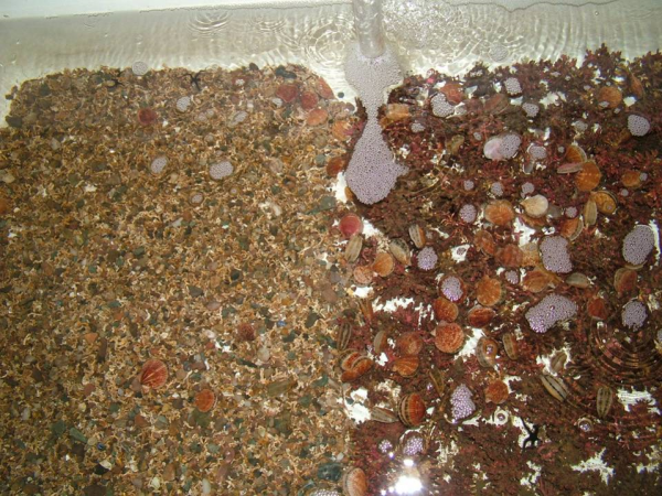
Queen scallop spat showing a preference for maerl (Nick Kamenos)
References:
For more information about the Isle of Man's Marine Nature Reserves, click here.
Posted up on 15th August 2020